Geologic structures (such as ore
bodies or faults) often produce small magnetic fields that distort the main
magnetic field of the earth. These distortions are called "anomalies" and can
be detected by measuring the magnetic field near the surface of the earth. By
processing and analyzing these measurements, geophysicists can learn about
geologic structures, even though the structures may be concealed entirely below
the Earth's surface.
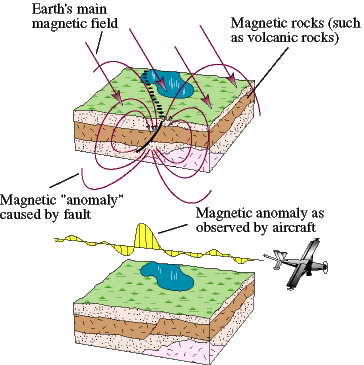
An aeromagnetic anomaly image
is usually made by a low-flying airplane that takes measurements along closely
spaced, parallel flight lines. Additional flight lines are flown in the
perpendicular direction to assist in data processing. The huge data set of
measurements is then processed into a digital aeromagnetic map.
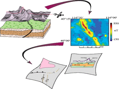
This thesis project aims to exploit
the spatial variations in the aeromagnetic data, i.e. its texture, in order to
extract additional structural and stratigraphic information,
which complements the information available from the raw data. Several textural
measures such as statistical features, the gray-level co-occurrence matrix, and
fractal transforms will be used to generate a suite of "derived images."
Currently, geophysicists use these processed images in conjunction with the geological
map of the region in order to manually interpret and label the rock
lithologies. The second goal of this project is to implement a pattern
classification algorithm that automates this labeling process in order
to, within certain error bounds, predict the geological structure of a
geographic region, given the raw aeromagnetic data. A picture depicting this
process is shown below.
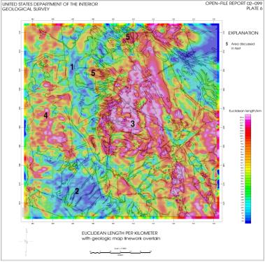
The image shown below is
the raw aeromagnetic map of the Santa Cruz Valley of Southern Arizona, along
with the surrounding Tumacacori, Patagonia, and Santa Rita Mountains, with an
overlay of a derived image that was generated using a texture measure referred
to as "Euclidian Length."
This work is a collaborative effort with Dr. Mark Gettings,
U.S. Geological Survey, Adjunct Professor, Dept. of Mining & Geological
Engineering.
Publications:
-
Vivek Shankar, Jeffrey J. Rodriguez, and Mark E. Gettings,
"Texture Analysis for Automated Classification of Geologic
Structures," 2006 IEEE Southwest Symp. on Image Analysis and
Interpretation, March 26-28, 2006, Denver, CO, pp. 81-85. [ PDF ]